
Running route at Altes AKH University Campus in Vienna
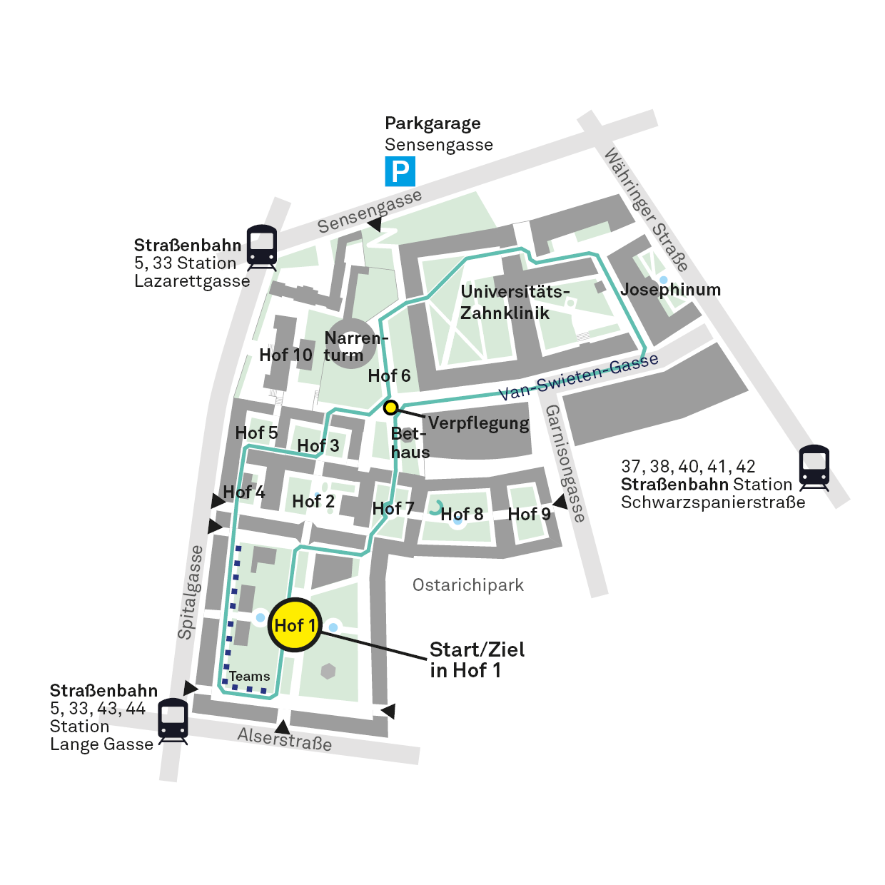
The 20th Cancer Research Run on 10 October 2026 will take place on the original circuit at the Altes AKH University Campus (Spitalgasse 2, 1090 Vienna).
If you’d like to take part in the Cancer Research Run but would prefer to run on a route of your own choosing, you can once again take part via the Distant Run – the main thing is that you join in.
To mark this anniversary, there’s a new feature: the centre – comprising the start, finish and stage – will be moved to Courtyard 1 of the Altes AKH Vienna University Campus.
Where do you run during the Distant Run?
Anyone can join our Strava Cancer Research Run Club as part of the Distant Run and choose their own route for the Cancer Research Run on 10 October. If the wide choice is giving you a headache, you can find some inspiration here. You can find all the information you need about taking part in the Strava Run Club here. With the help of the Cancer Research Run community, we’ve put together a few suggestions:
The extensive park, spanning some 52 hectares between the 2nd and 20th districts, is renowned for the Augarten Porcelain Manufactory and the Vienna Boys’ Choir, which are based there. It is also home to Vienna’s oldest Baroque garden complex; the park is a listed monument of garden architecture.
Melitta’s favourite running route is the Prater: “It’s simply beautiful there at any time of year and any time of day – whether in the morning or during your lunch break in summer – you’ll always find the right route for you. Even in autumn and winter, in the evening, when there might be a storm raging all around, it’s always just right there...”
Most people know the Vienna Prater from the Hauptallee, where Eliud Kipchoge set a fabulous marathon record of 1:59:40 on 12 October 2019. However, there’s not just fast tarmac on the 4.4-kilometre stretch between Praterstern and the “Lusthaus”; to the right and left of this, there are also picturesque single-track trails in the Praterauen, which cover an incredible 6 km².
For ultra-runners, there are links to the Danube Canal (e.g. at the Stadion and Rotunden bridges) and to the Danube Island (at Freudenau).
Stretching 17 kilometres, the Danube Canal winds its way through the centre of Vienna from Nussdorf in the north to Freudenau in the south, and has long since made a name for itself as a leisure haven. Both banks are fully developed along the entire route and are also popular with cyclists. Between Friedensbrücke and Urania, it can get a bit busier at times, whilst to the north and south of these points it is considerably less busy. The route from Nussdorf to Freudenau is mostly slightly downhill, whilst heading north is always slightly uphill. There are direct links from the Danube Canal to the Danube Island (at the Nussdorf lock and the Freudenau winter harbour), as well as to the Prater (several options between Franzensbrücke and Freudenau).
The route around Vienna’s Ringstrasse is 5.2 kilometres long and is dotted with sights. If you want to complete the loop, you’ll need to add a further 1.5 kilometres or so along the Kai/Danube Canal (between the Ringturm and the Urania). The entire route is well-developed as a footpath and cycle path amongst the tree-lined avenues, and if you fancy taking it at a leisurely pace, the stops at the traffic lights won’t bother you either.
Julian likes variety and usually runs along the Danube Canal, on the Danube Island, in Türkenschanzpark, along the Ring or in the Old AKH. He is planning his run for the Cancer Research Run in Schönbrunn Palace Park.
Countless kilometres of wide and narrow paths – mostly covered in fine gravel – wind their way through the 160-hectare park. From wide, flat and dead-straight stretches (from Hietzinger Tor to Meidlinger Tor = approx. 1 km) to single-track trails through the woods up to the Gloriette (60 metres of elevation gain), this running area offers something for everyone – including a sensational view of Vienna from the Gloriette.
Helmut and his company are organising a charity run for cancer research in the Lobau. This 22 km² floodplain on the eastern bank of the Danube, in the south of Vienna, is a nature reserve and one of the last major floodplain landscapes in Central Europe. The idyllic paths lead past ponds and pools; the area is home to more than 800 plant species, 30 species of mammals, 100 species of breeding birds, 8 species of reptiles, 13 species of amphibians and 60 species of fish.
Between Lainzer Tor and Empress Sisi’s Hermesvilla there is a flat, tarmac 2-kilometre loop; however, anyone wishing to really make the most of the Lainzer Tiergarten as a running area should be a bit more experienced, as the route involves some fairly steep ascents and descents. Between the Nikolaitor entrance and the Hirschgstemm or Rohrhaus, there is a height difference of around 200 metres, whilst the Hubertuswarte is a further 100 metres higher. In return, there are well-maintained, paved paths, information boards and plenty of shade: four-fifths of the 2,450-hectare nature reserve is woodland. A popular 22-kilometre route runs along the outside of the Lainzer-Tiergarten wall.
Tobias is a fan of Türkenschanzpark in the 18th district. One of the reasons is that there are so many ponds, streams and fountains here. The gently undulating terrain is criss-crossed by numerous tarmac paths. Whilst taking a break, you can also admire the many rare botanical specimens from all over the world that were planted here by the University of Natural Resources and Life Sciences.
This Viennese leisure paradise, situated between the Danube and the New Danube, is 21 kilometres long and 250 metres wide, and is easily accessible by public transport via several underground (U1, U2, U6) and rapid transit lines. On the main paths between the Nordbrücke and Reichsbrücke bridges, on fine days you’ll need to keep an eye out for cyclists, skaters, runners and pushchairs; the paths right along the banks of the Danube – and particularly to the north and south – are consistently less busy. The opposite banks also offer great opportunities: the “Treppelweg” at Handelskai takes you as far as the Prater or Klosterneuburg, whilst the Kaisermühlendamm leads all the way to the Lobau.
The idyllic path around Lake Erlauf is about five kilometres long; the lake lies at the foot of the Gemeindealpe and the border between Lower Austria and Styria runs through it. An initiative from Mariazell has already organised two charity runs here to raise money for cancer research.
The oldest surviving stately avenue in Central Europe is arguably the most beautiful route to Hellbrunn Palace. Teresa loves walking the roughly 2.5-kilometre gravel path lined with ancient trees, with views of the Untersberg and the meadows and fields of the protected landscape to the right and left of the avenue. What’s more, there’s always something to see as you pass Frohnburg Castle, the ‘Grill’ trout farm, the horse trough, where you can pause briefly to watch a rider and their horse, or Villa Emslieb, which belongs to the Ropac Gallery.
One of the most popular running routes in the city of Salzburg is undoubtedly that seemingly endless quay which runs through the city on both sides of the Salzach. If you start in the Mülln district, you run out of town past Salzburg’s old town as far as Hellbrunn – and further still, if you wish. Christina prefers to set off from Rudolfskai, right in the city centre, and then run past the Künstlerhaus to the Karolinenbrücke, cross over to the other side of the Salzach and run along the Volksgarten to the Überfuhrbrücke, where you can take a breather in a cosy pub with a lovely outdoor terrace.
‘Fräulein Flora’ has pored over walking maps, laced up her running shoes and worked up quite a sweat on test runs. The result is six running routes covering all levels of difficulty and every corner of the town.
- Salzachseen–Saalachspitz circuit: 6.8 km | 7 metres elevation gain
- Eichetwald–Almkanal circuit: 7.5 km | 10 metres elevation gain
- Plainberg circuit: 6.5 km | 130 metres elevation gain
- Ischlerbahn circuit: 8 km | 90 metres elevation gain
- Glasenbachklamm loop: 9 km | 230 metres elevation gain
- Fürstenbrunn–Walserwiesen loop: 11 km | 200 metres elevation gain